
Loading...
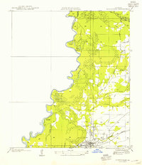
Loading map...1946 Map of Merryville
USGS Topo · Published 1946About this map
The Sabine River forms a winding border between Texas and Louisiana, where oxbow lakes and old river channels dominate the floodplain. Along the eastern banks in Beauregard Parish, the settlement of Merryville serves as a hub for the local timber and transport economy, situated at the intersection of the Gulf Colorado and Santa Fe railroad and the Logging rail lines that once penetrated the dense piney woods.
Find a feature on this map
31 named features on this map. Tap any name to fly to it.
Don’t see what you’re looking for? This feature index may not catch every label — zoom into the map to look around manually.
Map Details
Date Portrayed1946
Date Published1946
PublisherU.S. Geological Survey
Map TypeTopographic
Scale1:31,680
Physical Dimensions16.9 x 20.9 inches
Editions of this 1946 Merryville Map
This is the sole edition of this map. No revisions or reprints were ever made.
Historical Maps of Merryville Through Time
3 maps found
Featured Locations
Source Details
SourceU.S. Geological Survey
CopyrightPublic Domain