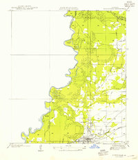
1954 Map of Merryville
USGS Topo · Published 1954About this map
The Sabine River forms a serpentine border between Louisiana and Texas, defining the western edge of this mid-century landscape. Just east of the river’s oxbows and sloughs, including Eaves Old River and Horseshoe Lake, the settlement of Merryville serves as a local hub. The map reveals a transition between the river lowlands and the higher piney woods, where a Logging Railroad and the Gulf Colorado and Santa Fe line intersect the terrain. This area was clearly shaped by the timber industry and river commerce, evidenced by the presence of Clines Ferry (Abandoned) and various logging grades. On the eastern side, local community life is anchored by landmarks like Bethlehem Ch and the Hennican Cem, while the small community of Junction sits near the confluence of Bayou Anacoco and the primary highway routes.
Find a feature on this map
30 named features on this map. Tap any name to fly to it.
Don’t see what you’re looking for? This feature index may not catch every label — zoom into the map to look around manually.
Map Details
Editions of this 1954 Merryville Map
This is the sole edition of this map. No revisions or reprints were ever made.
Other maps of this area

1935 · Wilson Lake
USGS Topo · 1:31,680

1946 · Merryville
USGS Topo · 1:31,680

1947 · Singer
USGS Topo · 1:31,680

1947 · Pujo
USGS Topo · 1:31,680

1947 · Knight
USGS Topo · 1:31,680

1947 · Wilson Lake
USGS Topo · 1:31,680

1947 · Bivens
USGS Topo · 1:31,680

1949 · Evans
USGS Topo · 1:31,680

1952 · Lake Charles
USGS Topo · 1:250,000
1954 · Pujo
USGS Topo · 1:31,680