1935 Map of Wilson Lake
USGS Topo · Published 1954About this map
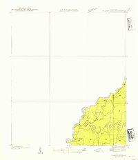
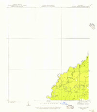
Sabine River waters define the western border of Beauregard Parish in this mid-1930s survey of the Louisiana-Texas state line. This map is characterized by a complex network of branching waterways and oxbows, illustrating the shifting nature of the river channel. The Old River and Middle River carve deep loops into the land, creating a mosaic of riverine islands and wetlands. Near the southern edge of the sheet, the namesake Wilson Lake and the uniquely named Bugger Branch further emphasize the low-lying, hydrologically active nature of this borderland. The absence of roads or structures on this advance sheet highlights the primitive state of the river bottomlands before major mid-century developments, providing a clear view of the natural topography along the Newton Co and Beauregard Parish boundary.
Find a feature on this map
7 named features on this map. Tap any name to fly to it.
Don’t see what you’re looking for? This feature index may not catch every label — zoom into the map to look around manually.
Map Details
Editions of this 1935 Wilson Lake Map
2 editions found
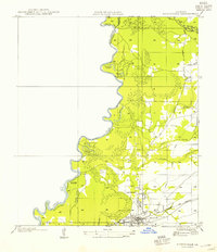
Other maps of this area

1946 · Merryville
USGS Topo · 1:31,680

1947 · Wilson Lake
USGS Topo · 1:31,680

1947 · Hyatt
USGS Topo · 1:31,680

1947 · Bivens
USGS Topo · 1:31,680

1949 · Bancroft
USGS Topo · 1:31,680

1952 · Lake Charles
USGS Topo · 1:250,000
1954 · Merryville
USGS Topo · 1:31,680

1954 · Bivens
USGS Topo · 1:31,680

1954 · Lake Charles
USGS Topo · 1:250,000

1955 · Hyatt
USGS Topo · 1:31,680