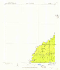
1935 Map of Wilson Lake
USGS Topo · Published 1956About this map
The Sabine River forms a complex boundary between Newton County, Texas, and Beauregard Parish, Louisiana, in this 1935 field examination. The landscape is defined by the shifting hydrology of the river basin, where multiple secondary channels like Middle River and Old River create a network of bottomlands and islands. Central to this area is Wilson Lake, a significant water body situated just east of the state line. The survey captures the intricate drainage patterns of the region, including smaller tributaries such as Bugger Branch, during a period before significant modern alteration. This map provides a detailed view of the natural topography and political boundaries at the Texas-Louisiana border, useful for understanding the historic watercourse of the Sabine.
Find a feature on this map
7 named features on this map. Tap any name to fly to it.
Don’t see what you’re looking for? This feature index may not catch every label — zoom into the map to look around manually.
Map Details
Editions of this 1935 Wilson Lake Map
2 editions found
Other maps of this area

1935 · Wilson Lake
USGS Topo · 1:31,680

1946 · Merryville
USGS Topo · 1:31,680

1947 · Wilson Lake
USGS Topo · 1:31,680

1947 · Hyatt
USGS Topo · 1:31,680

1947 · Bivens
USGS Topo · 1:31,680

1949 · Bancroft
USGS Topo · 1:31,680

1952 · Lake Charles
USGS Topo · 1:250,000
1954 · Merryville
USGS Topo · 1:31,680
1954 · Bivens
USGS Topo · 1:31,680

1954 · Lake Charles
USGS Topo · 1:250,000