
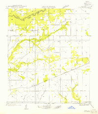
1947 Map of Bivens
USGS Topo · Published 1947About this map
The Sabine River forms the western boundary of this landscape, winding through a complex network of wetlands and oxbows such as Horseshoe Lake and Alligator Lake. The geography of the late 1930s and 1940s is defined by the transition from riverine commerce to inland timber and agriculture. In the south, the settlement of Bivens is anchored by Green Oak Ch and Boxwood Ch, while Merryville serves as the primary hub to the north. A significant relic of the region's industrial past is visible in the numerous segments of the Old Logging Railroad Grade, which crisscross the territory east of Johnson. These rail beds, alongside drainage features like Hoosier Creek and Pullem Branch, illustrate the systematic clearing and development of the Louisiana piney woods before the modernization of the local highway system.
Find a feature on this map
26 named features on this map. Tap any name to fly to it.
Don’t see what you’re looking for? This feature index may not catch every label — zoom into the map to look around manually.
Map Details
Editions of this 1947 Bivens Map
This is the sole edition of this map. No revisions or reprints were ever made.
Other maps of this area

1935 · Wilson Lake
USGS Topo · 1:31,680

1946 · Merryville
USGS Topo · 1:31,680

1947 · Singer
USGS Topo · 1:31,680

1947 · Pujo
USGS Topo · 1:31,680

1947 · Oretta
USGS Topo · 1:31,680

1947 · Wilson Lake
USGS Topo · 1:31,680

1947 · Hyatt
USGS Topo · 1:31,680

1949 · Bancroft
USGS Topo · 1:31,680

1952 · Lake Charles
USGS Topo · 1:250,000
1954 · Pujo
USGS Topo · 1:31,680