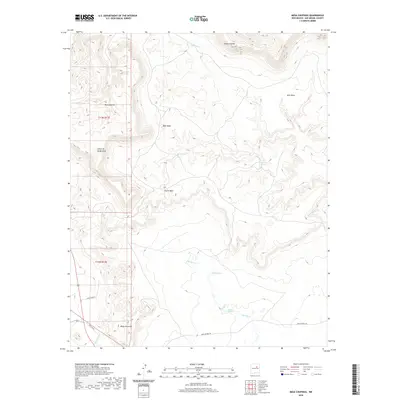
2020 Map of Mesa Chupinas
USGS Topo · Published 2020About this map
Mesa Chupinas rises as a prominent landmark in this high-elevation landscape within San Miguel County, where cattle ranching and seasonal water sources define the human footprint. The map documents the enduring presence of local ranching operations, specifically Lemita Ranch and Rael Ranch in the southwestern quadrant near Cañada Gomez. This terrain is characterized by a series of flat-topped landforms including West Mesa, East Mesa, and South Mesa, intersected by deeply cut drainages like Cañon de las Mujeras. These geographical features created natural boundaries for land use and movement through the region. Water is a critical resource in this arid environment, marked by numerous named points such as Deer Spring, Rincon Spring, and Alamito Springs, which likely served as vital hubs for livestock. A single major thoroughfare, Park Springs Rd, provides access across the lower elevations near Spring Cr.
Find a feature on this map
38 named features on this map. Tap any name to fly to it.
Don’t see what you’re looking for? This feature index may not catch every label — zoom into the map to look around manually.
Map Details
Editions of this 2020 Mesa Chupinas Map
This is the sole edition of this map. No revisions or reprints were ever made.
Other maps of this area

1890 · Bernal
USGS Topo · 1:125,000

1891 · Bernal
USGS Topo · 1:125,000

1892 · Corazon
USGS Topo · 1:125,000

1894 · Corazon
USGS Topo · 1:125,000

1894 · Bernal
USGS Topo · 1:125,000

1954 · Santa Fe
USGS Topo · 1:250,000

1958 · Santa Fe
USGS Topo · 1:250,000

1960 · Apache Springs
USGS Topo · 1:62,500

1963 · Pedro Miguel Peak
USGS Topo · 1:24,000
1963 · Chaperito
USGS Topo · 1:24,000