
1957 Map of Mesa
USGS Topo · Published 1957About this map
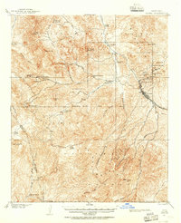
The Salt River and Gila River valleys define the landscape of this 1957 survey, illustrating the critical water management and agricultural patterns of central Arizona. In the west, the growing urban footprint of Phoenix, Tempe, and Mesa is clearly marked, alongside the educational presence of Arizona State College. The transition from the valley floor to the high desert is dominated by the Superstition Mountains and the mining activity near Miami and Globe, where the Inspiration Mine and Castle Dome Mine represent the region's industrial backbone. Northeast of the urban centers, the importance of water storage is evident through the series of reservoirs including Roosevelt Lake and Saguaro Lake on the Salt River. The eastern portion of the sheet provides a detailed look at the Fort Apache Indian Reservation and San Carlos Indian Reservation, showing the rugged terrain of the Mazatzal Mountains and the Sierra Ancha.
Find a feature on this map
77 named features on this map. Tap any name to fly to it.
Don’t see what you’re looking for? This feature index may not catch every label — zoom into the map to look around manually.
Map Details
Editions of this 1957 Mesa Map
This is the sole edition of this map. No revisions or reprints were ever made.
Other maps of this area

1886 · St Johns
USGS Topo · 1:250,000

1886 · Holbrook
USGS Topo · 1:250,000

1887 · Verde
USGS Topo · 1:250,000

1887 · Prescott
USGS Topo · 1:250,000

1892 · Verde
USGS Topo · 1:250,000

1892 · St Johns
USGS Topo · 1:250,000

1892 · Prescott
USGS Topo · 1:250,000

1893 · Holbrook
USGS Topo · 1:250,000

1900 · Florence
USGS Topo · 1:125,000
1901 · Globe
USGS Topo · 1:62,500