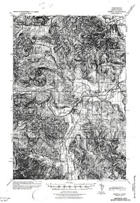
1941 Map of Meskill
USGS Topo · Published 1941About this map
The Chehalis River and its South Fork dictate the settlement patterns of this Lewis County region during the late 1930s. Major transportation corridors follow the river valleys, including the Northern Pacific and Chicago Milwaukee St Paul and Pacific railroads, which served the area's timber and agricultural interests. Industrial activity is evidenced by the Schafer Bros Logging Camp No 10 located in the northwest near the river bend.
Find a feature on this map
37 named features on this map. Tap any name to fly to it.
Don’t see what you’re looking for? This feature index may not catch every label — zoom into the map to look around manually.
Map Details
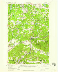
Editions of this 1941 Meskill Map
2 editions found
Other maps of this area

1916 · Chehalis
USGS Topo · 1:125,000

1940 · Tenino
USGS Topo · 1:62,500

1941 · Walville
USGS Topo · 1:62,500

1941 · Meskill
USGS Topo · 1:62,500

1941 · Olequa
USGS Topo · 1:62,500

1941 · Gate
USGS Topo · 1:62,500

1941 · Skamokawa
USGS Topo · 1:62,500

1941 · Ford
USGS Topo · 1:62,500

1944 · Tenino
USGS Topo · 1:62,500
1949 · Tenino
USGS Topo · 1:62,500