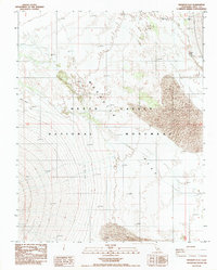
1988 Map of Mesquite Flat
USGS Topo · Published 1988About this map
Death Valley National Monument dominates this 1980s landscape, revealing the harsh and intricate hydrology of the Mesquite Flat basin. The area is characterized by scattered water sources essential for desert survival, including Surveyors Well, Midway Well, and Triangle Spring. These points represent critical nodes in the arid environment where sub-surface water reaches the surface, supporting the surrounding ecosystem.
Find a feature on this map
10 named features on this map. Tap any name to fly to it.
Don’t see what you’re looking for? This feature index may not catch every label — zoom into the map to look around manually.
Map Details
Editions of this 1988 Mesquite Flat Map
This is the sole edition of this map. No revisions or reprints were ever made.
Other maps of this area

1908 · Ballarat
USGS Topo · 1:250,000

1913 · Ballarat
USGS Topo · 1:250,000

1948 · Death Valley
USGS Topo · 1:250,000

1951 · Marble Canyon
USGS Topo · 1:62,500

1952 · Stovepipe Wells
USGS Topo · 1:62,500

1954 · Death Valley
USGS Topo · 1:250,000

1956 · Death Valley
USGS Topo · 1:250,000

1957 · Death Valley
USGS Topo · 1:250,000
1957 · Grapevine Peak
USGS Topo · 1:62,500

1957 · Tin Mountain
USGS Topo · 1:62,500