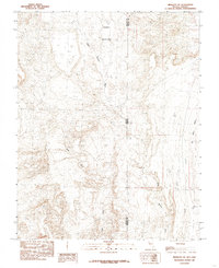
1985 Map of Mesquite NE
USGS Topo · Published 1985About this map
Terry Benches and Lone Mesa define the high ground of this desert landscape along the border of Nevada and Arizona. Recorded in the mid-1980s, the terrain is characterized by a complex network of seasonal drainage systems, including the prominent Sand Hollow Wash and Town Wash. The map reveals the precise intersection of Lincoln County and Mohave County, where the state lines meet amidst isolated landmarks like Tule Spring and the distinctive Castle Cliff. This survey captures the region's topographical transition toward Big Bend Wash and Coon Creek in the east, providing a detailed look at the land's natural contours and water channels before more recent development altered the character of these remote borderlands.
Find a feature on this map
16 named features on this map. Tap any name to fly to it.
Don’t see what you’re looking for? This feature index may not catch every label — zoom into the map to look around manually.
Map Details
Editions of this 1985 Mesquite NE Map
This is the sole edition of this map. No revisions or reprints were ever made.
Other maps of this area

1885 · St. George
USGS Topo · 1:250,000

1885 · Pioche
USGS Topo · 1:250,000

1886 · Saint Thomas
USGS Topo · 1:250,000

1886 · Mt. Trumbull
USGS Topo · 1:250,000

1886 · Pioche
USGS Topo · 1:250,000

1891 · St. George
USGS Topo · 1:250,000

1892 · Mt. Trumbull
USGS Topo · 1:250,000

1893 · Saint Thomas
USGS Topo · 1:250,000

1953 · Cedar City
USGS Topo · 1:250,000

1953 · Grand Canyon
USGS Topo · 1:250,000