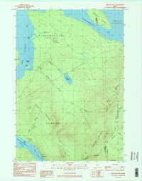
1984 Map of Metallak Mtn
USGS Topo · Published 1985About this map
Metallak Mountain and Elephant Mountain anchor this high-relief landscape in western Maine, defining the divide between several major water bodies. To the west, the shores of Upper Richardson Lake and Lower Richardson Lake are mapped in detail, including Black Point and the narrow waters of South Arm. This 1980s-era survey reveals a terrain dominated by timber-land management and recreational trekking rather than permanent settlement. The Appalachian Trail winds across the eastern ridges, traversing the crests of Bemis Mountain and passing near the heights of Old Blue Mtn. The hydrology of the region is intricate, with Metallak Stream and Icicle Brook draining the steep slopes into the expansive Mooselookmeguntic Lake, which features the large Toothaker Island in the northeast corner of the quadrangle.
Find a feature on this map
29 named features on this map. Tap any name to fly to it.
Don’t see what you’re looking for? This feature index may not catch every label — zoom into the map to look around manually.
Map Details
Editions of this 1984 Metallak Mtn Map
2 editions found
Other maps of this area

1927 · Rumford
USGS Topo · 1:48,000

1930 · Rumford
USGS Topo · 1:62,500

1933 · Rangeley
USGS Topo · 1:48,000

1939 · Rangeley
USGS Topo · 1:62,500

1940 · Oquossoc
USGS Topo · 1:62,500

1942 · Oquossoc
USGS Topo · 1:62,500

1943 · Old Speck Mtn
USGS Topo · 1:62,500

1945 · Old Speck Mtn
USGS Topo · 1:62,500

1949 · Rangeley
USGS Topo · 1:62,500

1950 · Lewiston
USGS Topo · 1:250,000