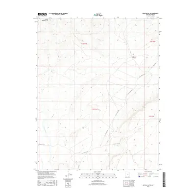
2017 Map of Mexican Hat SE
USGS Topo · Published 2017About this map
Halchita sits near the northwestern corner of this high-desert landscape, where the drainage systems of Halgaitoh Wash and Gypsum Cr cut through the arid terrain. The geography is defined by the broad expanse of Cane Valley and the seasonal waterway of Cane Valley Wash, which winds toward the south. Access to this remote corner of San Juan County is facilitated by a network of local routes including the C R 491 - Poncho House and the Cane Valley Wash Rd. These roads suggest a landscape of periodic industrial or ranching activity, evidenced by the presence of Mine Rd trailing into the southern hills. The map provides a detailed view of the Public Land Survey System, illustrating the township and range divisions of T42S and T43S across R19E and R20E.
Find a feature on this map
13 named features on this map. Tap any name to fly to it.
Don’t see what you’re looking for? This feature index may not catch every label — zoom into the map to look around manually.
Map Details
Editions of this 2017 Mexican Hat SE Map
This is the sole edition of this map. No revisions or reprints were ever made.
Other maps of this area

1886 · Abajo
USGS Topo · 1:250,000

1892 · Abajo
USGS Topo · 1:250,000

1892 · Canyon De Chelly
USGS Topo · 1:250,000

1893 · Abajo
USGS Topo · 1:250,000

1952 · Bluff 3 SE
USGS Topo · 1:24,000

1952 · Dinnehotso
USGS Topo · 1:62,500
1952 · Bluff 3 SW
USGS Topo · 1:24,000

1952 · Setsiltso Springs 2 NW
USGS Topo · 1:24,000

1952 · Setsiltso Springs 2 NE
USGS Topo · 1:24,000

1954 · Shiprock
USGS Topo · 1:250,000