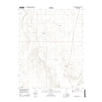
2014 Map of Mexican Water SW
USGS Topo · Published 2014About this map
Chinle Valley defines the landscape of this high desert region in the Navajo Nation, where vital water sources dictate the placement of local settlements and travel routes. Small communities like Sand Springs and Rock Point appear as sparse hubs of activity in a territory carved by seasonal drainages such as Chinle Wash and Tyende Cr. These watercourses, along with smaller features like Blackhorse Wash and Hummingbird Spring, were essential for life in an area bordered by distinctive formations like Skinny Mesa and Antelope Ridge. The arrival of modern transit is evident in the corridor of Us-191, which links these remote locales, while numerous Bureau of Indian Affairs routes like Bia-5052 and Bia-5023 provide a network for local access through the expansive range land.
Find a feature on this map
22 named features on this map. Tap any name to fly to it.
Don’t see what you’re looking for? This feature index may not catch every label — zoom into the map to look around manually.
Map Details
Editions of this 2014 Mexican Water SW Map
This is the sole edition of this map. No revisions or reprints were ever made.
Other maps of this area

1892 · Canyon De Chelly
USGS Topo · 1:250,000

1952 · Dinnehotso
USGS Topo · 1:62,500

1952 · Setsiltso Springs 2 SE
USGS Topo · 1:24,000

1952 · Setsiltso Springs 2 NE
USGS Topo · 1:24,000

1954 · Shiprock
USGS Topo · 1:250,000

1958 · Shiprock
USGS Topo · 1:250,000

1959 · Shiprock
USGS Topo · 1:250,000
1968 · Mexican Water
USGS Topo · 1:24,000
1968 · Hogansaani Spring
USGS Topo · 1:24,000
1968 · Walker Creek Reservoir
USGS Topo · 1:24,000