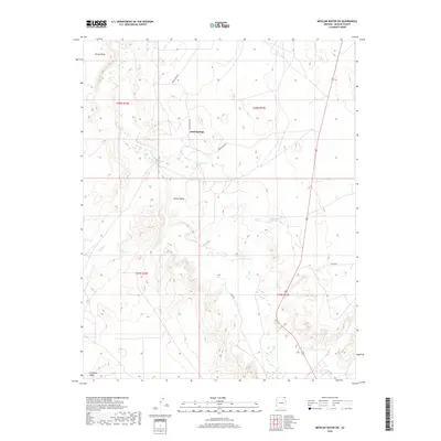
2018 Map of Mexican Water SW
USGS Topo · Published 2018About this map
Sand Springs serves as a central landmark in this high-desert landscape of northeastern Arizona, where the terrain is defined by the broad Chinle Valley and its system of seasonal drainages. The map illustrates a remote network of unpaved routes, including Indian Rte 5023 and Co Rd 487, which navigate between prominent geological formations like Skinny Mesa to the north and Antelope Ridge at the southern boundary. This area of the Shiprock Agency is characterized by its vital water sources in a dry climate, with Hummingbird Spring and Sunnyside Spring providing critical points of reference. The drainage patterns of Chinle Wash and Tyende Cr show how water moves through this part of Apache County, shaping the local geography near the turn of the 21st century.
Find a feature on this map
17 named features on this map. Tap any name to fly to it.
Don’t see what you’re looking for? This feature index may not catch every label — zoom into the map to look around manually.
Map Details
Editions of this 2018 Mexican Water SW Map
This is the sole edition of this map. No revisions or reprints were ever made.
Other maps of this area

1892 · Canyon De Chelly
USGS Topo · 1:250,000

1952 · Dinnehotso
USGS Topo · 1:62,500

1952 · Setsiltso Springs 2 SE
USGS Topo · 1:24,000

1952 · Setsiltso Springs 2 NE
USGS Topo · 1:24,000

1954 · Shiprock
USGS Topo · 1:250,000

1958 · Shiprock
USGS Topo · 1:250,000

1959 · Shiprock
USGS Topo · 1:250,000
1968 · Mexican Water
USGS Topo · 1:24,000
1968 · Hogansaani Spring
USGS Topo · 1:24,000
1968 · Walker Creek Reservoir
USGS Topo · 1:24,000