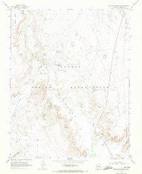
1968 Map of Mexican Water SW
USGS Topo · Published 1972About this map
Chinle Valley is the focal point of this late 1960s survey, illustrating a landscape defined by seasonal water sources and ancient history within the Navajo Indian Reservation. The map records several notable Cliff Dwellings along the eastern drainages, indicating long-standing indigenous habitation patterns across the high desert terrain. The water network is particularly detailed, showing essential survival points such as Hummingbird Spring, Sand Springs, and Sunnyside Spring, along with several flowing wells that sustained the area. The eastern edge of the sheet is marked by the Old Indian Treaty Boundary, a significant historical line in the region's geography. Prominent landforms like Skinny Mesa and Antelope Ridge border the broad wash of Chinle Wash, providing a clear view of the geological structure of this part of Apache County as it appeared just before the 1970s.
Find a feature on this map
17 named features on this map. Tap any name to fly to it.
Don’t see what you’re looking for? This feature index may not catch every label — zoom into the map to look around manually.
Map Details
Editions of this 1968 Mexican Water SW Map
This is the sole edition of this map. No revisions or reprints were ever made.
Other maps of this area

1892 · Canyon De Chelly
USGS Topo · 1:250,000

1952 · Dinnehotso
USGS Topo · 1:62,500

1952 · Setsiltso Springs 2 SE
USGS Topo · 1:24,000

1952 · Setsiltso Springs 2 NE
USGS Topo · 1:24,000

1954 · Shiprock
USGS Topo · 1:250,000

1958 · Shiprock
USGS Topo · 1:250,000

1959 · Shiprock
USGS Topo · 1:250,000
1968 · Mexican Water
USGS Topo · 1:24,000
1968 · Hogansaani Spring
USGS Topo · 1:24,000
1968 · Walker Creek Reservoir
USGS Topo · 1:24,000