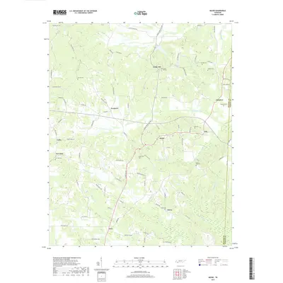
2019 Map of Michie
USGS Topo · Published 2019About this map
Michie serves as a central hub in this corner of McNairy County, where the landscape is defined by the headwaters of Lick Cr and its engineered Lick Creek Canal. The rural settlement pattern is deeply rooted in local genealogy, evidenced by numerous family and community burial grounds such as Sand Hill Cem, Lebanon Cem, and Carter Cem. Small hamlets and crossroads like Tulu, Pebble Hill, and Needmore are linked by a network of named country roads, including Michie Pebble Hill Rd and Taylor Rd. To the south, the community of Acton sits near the drainage of Chambers Cr, while the eastern boundary is marked by the line between McNairy and Hardin Counties. The terrain is a complex web of small drainages like Donald Springs Br and Little Lick Cr, illustrating the traditional agricultural and timber-based layout of southern Tennessee.
Find a feature on this map
92 named features on this map. Tap any name to fly to it.
Don’t see what you’re looking for? This feature index may not catch every label — zoom into the map to look around manually.
Map Details
Editions of this 2019 Michie Map
This is the sole edition of this map. No revisions or reprints were ever made.
Other maps of this area

1935 · Doskie
USGS Topo · 1:24,000

1936 · Counce
USGS Topo · 1:24,000

1936 · Kendrick
USGS Topo · 1:24,000

1936 · Pittsburg Landing
USGS Topo · 1:24,000

1936 · Purdy
USGS Topo · 1:24,000

1936 · Stantonville
USGS Topo · 1:24,000

1936 · Michie
USGS Topo · 1:24,000

1949 · Pittsburg Landing
USGS Topo · 1:24,000

1949 · Purdy
USGS Topo · 1:24,000

1949 · Stantonville
USGS Topo · 1:24,000