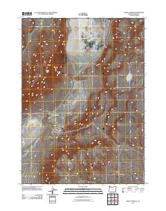
2011 Map of Mickey Springs
USGS Topo · Published 2011About this map
Mickey Butte dominates the arid landscape of this Harney County region, overlooking the expansive depression of Mickey Basin. This USGS survey documents a high-desert environment where water sources are vital but sparse. The namesake Mickey Springs and the northern Crippled Horse Spring represent critical water points in an otherwise dry drainage network. Further east, the map identifies Ancient Lake, providing evidence of the area's prehistoric hydrology. The lack of structured settlements or schools indicates the persistent isolation of this territory, where the infrastructure is limited to secondary roads and trails that navigate between volcanic features and dry lake beds.
Find a feature on this map
5 named features on this map. Tap any name to fly to it.
Don’t see what you’re looking for? This feature index may not catch every label — zoom into the map to look around manually.
Map Details
Editions of this 2011 Mickey Springs Map
This is the sole edition of this map. No revisions or reprints were ever made.
Other maps of this area

1955 · Adel
USGS Topo · 1:250,000

1957 · Adel
USGS Topo · 1:250,000

1958 · Adel
USGS Topo · 1:250,000

1962 · Adel
USGS Topo · 1:250,000

1981 · Coyote Lake West
USGS Topo · 1:24,000
1981 · Mann Lake
USGS Topo · 1:24,000
1981 · Johnny Creek SW
USGS Topo · 1:24,000

1981 · Ancient Lake Well
USGS Topo · 1:24,000

1981 · Miranda Flat SW
USGS Topo · 1:24,000

1981 · Miranda Flat SE
USGS Topo · 1:24,000