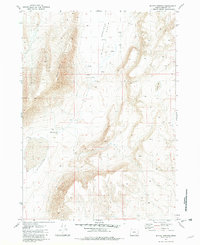
1981 Map of Mickey Springs
USGS Topo · Published 1982About this map
Mickey Depression Basin dominates this landscape, revealing a stark geological environment in Harney County as it was documented in the late 1970s and early 1980s. The high-desert terrain is punctuated by the geothermal activity of Mickey Springs (Hot), located near the foot of Mickey Butte. Evidence of human settlement and ranching efforts in this arid basin is sparse, marked primarily by the Mickey Cabin, a Corral, and scattered Ruins. These features, along with several unnamed seasonal springs, suggest a history of intermittent land use where water was the primary constraint. The map also identifies the bed of an Ancient Lake, providing a window into the region's deeper environmental history. Travel through the basin is limited, shown primarily as 4wd tracks that connect the few established landmarks and water sources.
Find a feature on this map
13 named features on this map. Tap any name to fly to it.
Don’t see what you’re looking for? This feature index may not catch every label — zoom into the map to look around manually.
Map Details
Editions of this 1981 Mickey Springs Map
This is the sole edition of this map. No revisions or reprints were ever made.
Other maps of this area

1955 · Adel
USGS Topo · 1:250,000

1957 · Adel
USGS Topo · 1:250,000

1958 · Adel
USGS Topo · 1:250,000

1962 · Adel
USGS Topo · 1:250,000

1981 · Coyote Lake West
USGS Topo · 1:24,000
1981 · Mann Lake
USGS Topo · 1:24,000
1981 · Johnny Creek SW
USGS Topo · 1:24,000

1981 · Ancient Lake Well
USGS Topo · 1:24,000

1981 · Miranda Flat SW
USGS Topo · 1:24,000

1981 · Miranda Flat SE
USGS Topo · 1:24,000