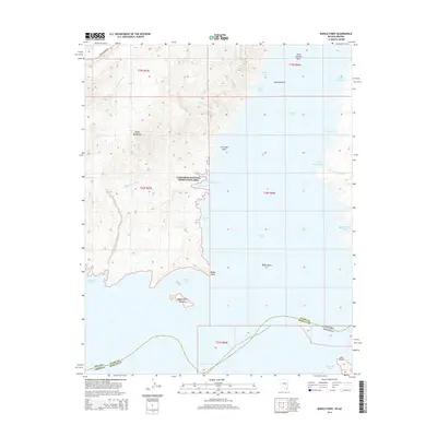
2014 Map of Middle Point
USGS Topo · Published 2014About this map
The Black Mountains dominate the western terrain of this landscape, where steep slopes descend toward the expansive waters of Lake Mead. This area is preserved as part of the Lake Mead National Recreation Area, showing a complex shoreline defined by significant inlets such as Overton Arm and the broad Virgin Basin. The map captures the boundary where Nevada and Arizona meet in the south, marked by the meeting of Clark County and Mohave County. Notable landforms like Kitty Coleman Rock, Jim Jones Reef, and Surprise Reef provide critical landmarks for navigation and geological study. The network of dry washes, including Cleopatra Wash and Manganese Wash, illustrates the drainage patterns that feed into numerous coves like Ebony Cove and Boathouse Cove. The isolated Middle Point Islands sit just off the prominent peninsula of Middle Point, highlighting the fluctuating relationship between the desert topography and the reservoir's reach.
Find a feature on this map
34 named features on this map. Tap any name to fly to it.
Don’t see what you’re looking for? This feature index may not catch every label — zoom into the map to look around manually.
Map Details
Editions of this 2014 Middle Point Map
This is the sole edition of this map. No revisions or reprints were ever made.
Other maps of this area

1886 · Saint Thomas
USGS Topo · 1:250,000

1893 · Saint Thomas
USGS Topo · 1:250,000

1926 · Bonelli
USGS Topo · 1:96,000

1926 · Boulder Canyon
USGS Topo · 1:96,000

1953 · Muddy Peak
USGS Topo · 1:62,500

1953 · Overton Beach
USGS Topo · 1:62,500

1953 · Hoover Dam
USGS Topo · 1:62,500

1953 · Virgin Basin
USGS Topo · 1:62,500

1954 · Las Vegas
USGS Topo · 1:250,000

1957 · Las Vegas
USGS Topo · 1:250,000