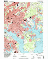
1998 Map of Middle River
USGS Topo · Published 2000About this map
The sprawling shoreline of Middle River Neck and its numerous creeks define this detailed late-20th-century landscape east of Baltimore. The map highlights the significant aviation and military footprint of the region, anchored by the Martin State Airport, a National Guard presence, and the Essex Skypark. Residential developments like Aero Acres and Victory Villa are shown alongside the intricate network of tidal waterways, including Frog Mortar Creek and Dark Head Creek.
Find a feature on this map
117 named features on this map. Tap any name to fly to it.
Don’t see what you’re looking for? This feature index may not catch every label — zoom into the map to look around manually.
Map Details
Editions of this 1998 Middle River Map
This is the sole edition of this map. No revisions or reprints were ever made.
Other maps of this area

1893 · North Point
USGS Topo · 1:62,500

1893 · Gunpowder
USGS Topo · 1:62,500

1894 · Baltimore
USGS Topo · 1:62,500

1894 · Relay
USGS Topo · 1:62,500

1898 · Tolchester
USGS Topo · 1:125,000

1899 · Baltimore
USGS Topo · 1:62,500

1901 · Gunpowder
USGS Topo · 1:62,500

1903 · Tolchester
USGS Topo · 1:125,000

1904 · Baltimore
USGS Topo · 1:62,500

1904 · North Point
USGS Topo · 1:62,500