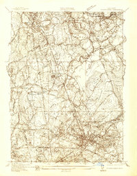
1937 Map of Middleboro
USGS Topo · Published 1937About this map
Middleboro serves as the primary hub of this landscape, where the New York New Haven and Hartford railroad lines converge amidst a complex network of wetlands and rivers. The settlement pattern is defined by the massive Great Cedar Swamp and Meetinghouse Swamp, which separate distinct villages such as North Middleboro and Thompsonville. Local industry and agriculture are evident in the numerous cranberry bogs, including the Attwood Bogs and Washburn Bogs, while the State Farm and the Sewage Disposal Plant highlight mid-century institutional development.
Find a feature on this map
55 named features on this map. Tap any name to fly to it.
Don’t see what you’re looking for? This feature index may not catch every label — zoom into the map to look around manually.
Map Details
Editions of this 1937 Middleboro Map
This is the sole edition of this map. No revisions or reprints were ever made.
Other maps of this area

1885 · Abington
USGS Topo · 1:62,500

1885 · Middleboro
USGS Topo · 1:62,500

1885 · Taunton
USGS Topo · 1:62,500

1886 · Dedham
USGS Topo · 1:62,500

1888 · Taunton
USGS Topo · 1:62,500

1888 · Middleboro
USGS Topo · 1:62,500

1888 · Abington
USGS Topo · 1:62,500

1893 · Abington
USGS Topo · 1:62,500

1893 · Taunton
USGS Topo · 1:62,500

1893 · Middleboro
USGS Topo · 1:62,500