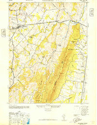
1946 Map of Middleburg
USGS Topo · Published 1946About this map
The town of Middleburg and the village of Aldie anchor this mid-century survey of the Northern Virginia hunt country, where the landscape is defined by the sharp rise of the Bull Run Mountains. The Lee-Jackson Memorial Highway serves as the primary east-west artery, connecting these Piedmont settlements through a terrain of ridges and valleys. Evidence of the rural community structure is visible in the placement of landmarks like the Bull Run Sch near Buchannon Gap and the cluster of Grace Ch and Hickory Grove Ch to the southeast.
Find a feature on this map
38 named features on this map. Tap any name to fly to it.
Don’t see what you’re looking for? This feature index may not catch every label — zoom into the map to look around manually.
Map Details
Editions of this 1946 Middleburg Map
This is the sole edition of this map. No revisions or reprints were ever made.
Other maps of this area

1884 · Harpers Ferry
USGS Topo · 1:125,000

1891 · Harpers Ferry
USGS Topo · 1:125,000

1893 · Harpers Ferry
USGS Topo · 1:125,000

1894 · Warrenton
USGS Topo · 1:125,000

1916 · Berryville
USGS Topo · 1:62,500

1933 · Middleburg
USGS Topo · 1:62,500

1939 · Berryville
USGS Topo · 1:48,000

1943 · Arcola
USGS Topo · 1:24,000

1943 · Bluemont
USGS Topo · 1:24,000

1943 · Thorofare Gap
USGS Topo · 1:24,000