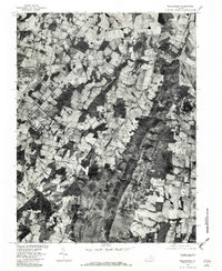
1977 Map of Middleburg
USGS Topo · Published 1982About this map
Middleburg and Aldie anchor this 1977 orthophotoquad, which uses rectified aerial photography to document the Virginia Piedmont landscape in high detail. Unlike traditional topographic maps, this imagery reveals the exact patchwork of woodlots, fenced pastures, and estates that characterize this storied horse country. The terrain is dominated by the north-south ridge of the Bull Run Mountains, which creates a sharp geographic divide punctuated by Buchannon Gap.
Find a feature on this map
11 named features on this map. Tap any name to fly to it.
Don’t see what you’re looking for? This feature index may not catch every label — zoom into the map to look around manually.
Map Details
Editions of this 1977 Middleburg Map
This is the sole edition of this map. No revisions or reprints were ever made.
Other maps of this area

1884 · Harpers Ferry
USGS Topo · 1:125,000

1891 · Harpers Ferry
USGS Topo · 1:125,000

1893 · Harpers Ferry
USGS Topo · 1:125,000

1894 · Warrenton
USGS Topo · 1:125,000

1916 · Berryville
USGS Topo · 1:62,500

1933 · Middleburg
USGS Topo · 1:62,500

1939 · Berryville
USGS Topo · 1:48,000

1943 · Arcola
USGS Topo · 1:24,000

1943 · Bluemont
USGS Topo · 1:24,000

1943 · Thorofare Gap
USGS Topo · 1:24,000