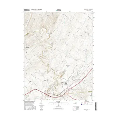
2016 Map of Middletown
USGS Topo · Published 2016About this map
Cedar Creek and Belle Grove National Historical Park anchors this portion of the Shenandoah Valley, where the borders of Frederick, Shenandoah, and Warren counties converge. The landscape is defined by the winding course of Cedar Creek, which serves as a natural boundary between several small settlements and rural homesteads. At the southern edge of the sheet, the town of Strasburg sits near the intersection of major transit corridors like the Valley Pike, while Middletown serves as a central hub further north. This region is deeply layered with colonial and Civil War history, evidenced by landmarks such as Stephens Fort, Nieswanders Fort, and the Cedar Creek Battlefield. Local genealogy is well-represented through numerous family and community burial grounds, including Quaker Cem, Stickley Cem, and Walnut Springs Cem. The terrain rises toward Little North Mountain and Pangletown Ridge, shaping the drainage patterns of numerous local runs and hollows.
Find a feature on this map
143 named features on this map. Tap any name to fly to it.
Don’t see what you’re looking for? This feature index may not catch every label — zoom into the map to look around manually.
Map Details
Editions of this 2016 Middletown Map
This is the sole edition of this map. No revisions or reprints were ever made.
Other maps of this area

1893 · Luray
USGS Topo · 1:125,000

1894 · Winchester
USGS Topo · 1:125,000

1905 · Luray
USGS Topo · 1:125,000

1923 · Middletown
USGS Topo · 1:62,500

1937 · Middletown
USGS Topo · 1:48,000

1938 · Winchester
USGS Topo · 1:48,000

1939 · Front Royal
USGS Topo · 1:48,000

1942 · Winchester
USGS Topo · 1:62,500

1943 · Middletown
USGS Topo · 1:62,500

1944 · Front Royal
USGS Topo · 1:62,500