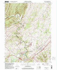
1999 Map of Middletown
USGS Topo · Published 2000About this map
The winding Cedar Creek carves a deep valley through the limestone landscapes of Frederick and Shenandoah counties, anchoring a region defined by its Civil War heritage. This area is famously dominated by the Cedar Creek Battlefield, where the 19th-century conflict left an indelible mark on the countryside. The town of Middletown stands as a central hub, surrounded by smaller rural settlements like Meadow Mills, Oranda, and Wheatfield.
Find a feature on this map
52 named features on this map. Tap any name to fly to it.
Don’t see what you’re looking for? This feature index may not catch every label — zoom into the map to look around manually.
Map Details
Editions of this 1999 Middletown Map
This is the sole edition of this map. No revisions or reprints were ever made.
Other maps of this area

1893 · Luray
USGS Topo · 1:125,000

1894 · Winchester
USGS Topo · 1:125,000

1905 · Luray
USGS Topo · 1:125,000

1923 · Middletown
USGS Topo · 1:62,500

1937 · Middletown
USGS Topo · 1:48,000

1938 · Winchester
USGS Topo · 1:48,000

1939 · Front Royal
USGS Topo · 1:48,000

1942 · Winchester
USGS Topo · 1:62,500

1943 · Middletown
USGS Topo · 1:62,500

1944 · Front Royal
USGS Topo · 1:62,500