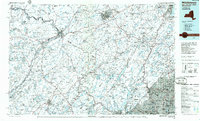
1986 Map of Middletown
USGS Topo · Published 1986About this map
The Hudson River corridor and the mountain gaps of the Tri-State region define this mid-1980s landscape, anchored by the U.S. Military Academy (West Point) and the Picatinny Arsenal. The map illustrates a complex network of transportation and protected lands, showing the intersection of Conrail lines and the New York Susquehanna & Western RR with major arteries like the New York State Thruway and Interstate 84.
Find a feature on this map
205 named features on this map. Tap any name to fly to it.
Don’t see what you’re looking for? This feature index may not catch every label — zoom into the map to look around manually.
Map Details
Editions of this 1986 Middletown Map
2 editions found
Other maps of this area

1888 · Franklin
USGS Topo · 1:62,500

1888 · Morristown
USGS Topo · 1:62,500

1888 · Hackettstown
USGS Topo · 1:62,500

1888 · Lake Hopatcong
USGS Topo · 1:62,500

1888 · Paterson
USGS Topo · 1:62,500

1891 · Greenwood Lake
USGS Topo · 1:62,500

1891 · Ramapo
USGS Topo · 1:62,500

1891 · Harlem
USGS Topo · 1:62,500

1891 · Wallpack
USGS Topo · 1:62,500

1891 · Delaware Water Gap
USGS Topo · 1:62,500