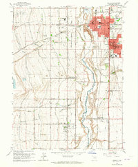
1963 Map of Midvale
USGS Topo · Published 1964About this map
The Jordan River corridor south of Salt Lake City reveals a landscape of rapidly expanding post-war suburbanization alongside deep-rooted agricultural and industrial infrastructure. The city of Midvale serves as a primary hub, while the presence of the Sugar Refinery and various canals like the Utah and Salt Lake Canal and South Jordan Canal highlight the region's productive heritage. The rail network remains a dominant feature, with both the Denver and Rio Grande Western RR and the Union Pacific RR servicing industrial sidings and connecting the disparate settlements of South Jordan, Riverton, and Sandy City. To the west, the Salt Lake City Municipal Airport No 2 and the Utah State Prison occupy significant footprints on the valley floor, while numerous cemeteries including Wite Fort Cem and Lake Hill Cemetery provide critical data points for local genealogy.
Find a feature on this map
48 named features on this map. Tap any name to fly to it.
Don’t see what you’re looking for? This feature index may not catch every label — zoom into the map to look around manually.
Map Details
Editions of this 1963 Midvale Map
3 editions found
Other maps of this area

1885 · Salt Lake
USGS Topo · 1:250,000

1885 · Tooele Valley
USGS Topo · 1:250,000

1915 · Fairfield
USGS Topo · 1:62,500

1917 · Fairfield
USGS Topo · 1:62,500

1925 · Ft. Douglas
USGS Topo · 1:125,000

1928 · Ft. Douglas
USGS Topo · 1:125,000

1951 · Jordan Narrows
USGS Topo · 1:24,000

1951 · Lehi
USGS Topo · 1:24,000

1951 · Salt Lake City South
USGS Topo · 1:24,000

1951 · Midvale
USGS Topo · 1:24,000