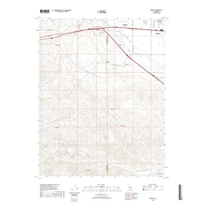
2018 Map of Midway
USGS Topo · Published 2018About this map
The eastern foothills of the Diablo Range meet the flat expanses of the Central Valley in this detailed survey of the San Joaquin and Alameda county line. The settlement of Midway serves as a central point where the complex water infrastructure of the region—including the Governor Edmund G Brown California Aqueduct and the Delta-Mendota Canal—navigates the transition from the hills to the valley floor. To the north, the growing community of Mountain House and the outskirts of Tracy illustrate the modern residential expansion into what was traditionally ranching and transit land near Altamont Pass Rd. In the southern half of the map, the terrain becomes increasingly complex, characterized by deep cuts like Elk Ravine and Mitchell Ravine that drain toward Corral Hollow Cr. This area preserves the rugged character of the historical Corral Hollow corridor, once a vital passage through the coast ranges.
Find a feature on this map
43 named features on this map. Tap any name to fly to it.
Don’t see what you’re looking for? This feature index may not catch every label — zoom into the map to look around manually.
Map Details
Editions of this 2018 Midway Map
This is the sole edition of this map. No revisions or reprints were ever made.
Other maps of this area

1907 · Tesla
USGS Topo · 1:62,500

1911 · Byron Hot Springs
USGS Topo · 1:31,680

1914 · Bethany
USGS Topo · 1:31,680

1914 · Union Island
USGS Topo · 1:31,680

1916 · Byron Hot Springs
USGS Topo · 1:31,680

1916 · Byron
USGS Topo · 1:62,500

1916 · Tracy
USGS Topo · 1:31,680

1916 · Midway
USGS Topo · 1:31,680

1922 · Carbona
USGS Topo · 1:62,500

1940 · Byron
USGS Topo · 1:62,500