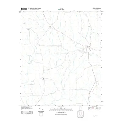
2011 Map of Midway
USGS Topo · Published 2011About this map
The Pea River and its numerous tributaries, including Bluff Creek and Johnson Creek, define the rural landscape of this Bullock County region. Centered on the settlement of Midway, the map reveals a community deeply rooted in its local geography, with a remarkably dense concentration of family and community burial grounds. These include the Midway Cemetery, Antioch Church Cemetery, and Mount Azure Cemetery, among others, offering significant value for genealogical research in southeastern Alabama. The historic Three Notch settlement appears in the northern section, positioned near the intersection of several county roads. The transport network is characterized by established routes like Old Union Springs Rd and 3 Notch Rd, which reflect the area's long-standing connection to nearby trade centers. Small hamlets like Pine Grove and natural features such as Fishers Lake provide further evidence of the dispersed, agricultural settlement pattern typical of the era.
Find a feature on this map
37 named features on this map. Tap any name to fly to it.
Don’t see what you’re looking for? This feature index may not catch every label — zoom into the map to look around manually.
Map Details
Editions of this 2011 Midway Map
This is the sole edition of this map. No revisions or reprints were ever made.
Other maps of this area

1953 · Dothan
USGS Topo · 1:250,000

1954 · Dothan
USGS Topo · 1:250,000

1955 · Dothan
USGS Topo · 1:250,000

1955 · Phenix City
USGS Topo · 1:250,000

1957 · Phenix City
USGS Topo · 1:250,000

1958 · Phenix City
USGS Topo · 1:250,000

1968 · Clayton North
USGS Topo · 1:24,000

1968 · Perote
USGS Topo · 1:24,000

1968 · Mount Andrew
USGS Topo · 1:24,000
1973 · Comer
USGS Topo · 1:24,000