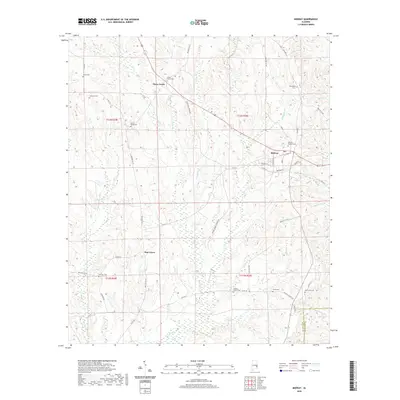
2020 Map of Midway
USGS Topo · Published 2020About this map
Midway serves as the primary hub of this East Alabama landscape, where the local street grid intersects with several significant regional routes. The settlement's history is anchored by sites like Midway Baptist Cem, while nearby Three Notch and Pine Grove indicate the persistent rural community structure of Bullock County. The topography is defined by the drainage systems of the Pea River and S Fork Cowikee Cr, creating a rolling terrain that once supported a robust agrarian economy. Genealogists will find a high density of family and community burial sites, including the Peniel Cem, Johnston Cem, and Lewis Cem. Further out, the landscape is dotted with spiritual landmarks such as Antioch Church and the Mount Azure Cem, marking the enduring social and religious centers that have defined the area for generations.
Find a feature on this map
55 named features on this map. Tap any name to fly to it.
Don’t see what you’re looking for? This feature index may not catch every label — zoom into the map to look around manually.
Map Details
Editions of this 2020 Midway Map
This is the sole edition of this map. No revisions or reprints were ever made.
Other maps of this area

1953 · Dothan
USGS Topo · 1:250,000

1954 · Dothan
USGS Topo · 1:250,000

1955 · Dothan
USGS Topo · 1:250,000

1955 · Phenix City
USGS Topo · 1:250,000

1957 · Phenix City
USGS Topo · 1:250,000

1958 · Phenix City
USGS Topo · 1:250,000

1968 · Clayton North
USGS Topo · 1:24,000

1968 · Perote
USGS Topo · 1:24,000

1968 · Mount Andrew
USGS Topo · 1:24,000
1973 · Comer
USGS Topo · 1:24,000