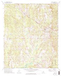
1973 Map of Midway
USGS Topo · Published 1976About this map
The town of Midway sits at the junction of rail and road in the southeastern Alabama countryside, defined by a landscape of creek valleys and historic boundaries. This 1970s survey captures the area as the Central of Georgia railroad cut through the terrain, connecting the settlement to Three Notch in the northwest. A notable historical feature is the Indian Treaty Boundary, which runs diagonally across the quadrangle, marking an older era of land division. The map is particularly rich for genealogical research, documenting numerous rural burial sites and congregations such as Peniel Cem, Mt Azure Ch, and Fellowship Cem. To the east, the terrain transitions into the Barbour County State Wildlife Management Area, while the Pea River and Bluff Creek drain the surrounding hills, reflecting a region where timber and small-town commerce remained central to local life.
Find a feature on this map
28 named features on this map. Tap any name to fly to it.
Don’t see what you’re looking for? This feature index may not catch every label — zoom into the map to look around manually.
Map Details
Editions of this 1973 Midway Map
This is the sole edition of this map. No revisions or reprints were ever made.
Other maps of this area

1953 · Dothan
USGS Topo · 1:250,000

1954 · Dothan
USGS Topo · 1:250,000

1955 · Dothan
USGS Topo · 1:250,000

1955 · Phenix City
USGS Topo · 1:250,000

1957 · Phenix City
USGS Topo · 1:250,000

1958 · Phenix City
USGS Topo · 1:250,000

1968 · Clayton North
USGS Topo · 1:24,000

1968 · Perote
USGS Topo · 1:24,000

1968 · Mount Andrew
USGS Topo · 1:24,000
1973 · Comer
USGS Topo · 1:24,000