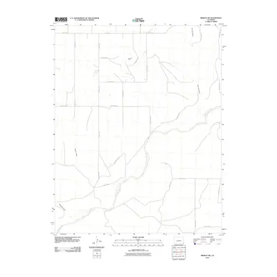
2010 Map of Midway SW
USGS Topo · Published 2010About this map
Flank Oil Field stands as a primary industrial marker in this corner of Baca County, where the high plains terrain is defined more by its drainage patterns than by dense settlement. The Cimarron River winds through the southern portion of the quadrangle, creating a distinct riparian corridor that contrasts with the surrounding tablelands. This landscape is deeply etched by significant geographic depressions, including Spring Canyon in the northeast and both Moore Draw and Mitchell Draw to the west. A precise grid of section roads, including County Rd K and County Rd 53, facilitates access across the open range, illustrating the systematic land division and transport network necessary for maintaining the region's energy and ranching operations during the early 21st century.
Find a feature on this map
21 named features on this map. Tap any name to fly to it.
Don’t see what you’re looking for? This feature index may not catch every label — zoom into the map to look around manually.
Map Details
Editions of this 2010 Midway SW Map
This is the sole edition of this map. No revisions or reprints were ever made.
Other maps of this area

1892 · Vilas
USGS Topo · 1:125,000

1954 · Dalhart
USGS Topo · 1:250,000

1955 · La Junta
USGS Topo · 1:250,000

1958 · La Junta
USGS Topo · 1:250,000

1958 · Dalhart
USGS Topo · 1:250,000

1962 · Dalhart
USGS Topo · 1:250,000

1968 · La Junta
USGS Topo · 1:250,000

1971 · Sturgis
USGS Topo · 1:24,000

1971 · Keyes NE
USGS Topo · 1:24,000
1971 · Sturgis NW
USGS Topo · 1:24,000