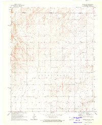
1971 Map of Sturgis NW
USGS Topo · Published 1973About this map
The Colorado-Oklahoma border cuts across the northern edge of this 1970s landscape, marking the transition between Baca County and Cimarron County. The terrain is defined by the sweeping curves of the Cimarron River as it winds through the northwest, while Goff Creek flows across the southern reaches. This is an active energy landscape, characterized by an extensive Oil Field and dozens of individual extractive sites. Genealogists and local historians can find a dense network of Gas Wells and Oil Wells scattered throughout the central and eastern sections, reflecting the mid-century industrial footprint on this high plains territory. Notable landforms like Sandy Hook provide geological context to a region shaped by both its natural hydrology and subterranean resources.
Find a feature on this map
9 named features on this map. Tap any name to fly to it.
Don’t see what you’re looking for? This feature index may not catch every label — zoom into the map to look around manually.
Map Details
Editions of this 1971 Sturgis NW Map
This is the sole edition of this map. No revisions or reprints were ever made.
Other maps of this area

1892 · Vilas
USGS Topo · 1:125,000

1954 · Dalhart
USGS Topo · 1:250,000

1955 · La Junta
USGS Topo · 1:250,000

1958 · La Junta
USGS Topo · 1:250,000

1958 · Dalhart
USGS Topo · 1:250,000

1962 · Dalhart
USGS Topo · 1:250,000

1968 · La Junta
USGS Topo · 1:250,000

1971 · Sturgis
USGS Topo · 1:24,000

1971 · Keyes West
USGS Topo · 1:24,000

1971 · Hopkins
USGS Topo · 1:24,000