
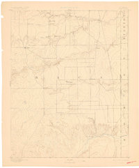
1892 Map of Vilas
USGS Topo · Published 1892About this map
The high plains of southeastern Baca County, Colorado, are documented here just as the frontier period was giving way to more permanent ranching and early townsite development. The landscape is defined by its drainage systems, with the Cimarron River flowing across the southern edge and Horse Creek and Antelope Creek cutting through the northern reaches. The presence of the Texas Trail crossing the eastern border into Stanton County, Kansas, highlights the region's importance as a corridor for cattle drives and western migration during the late nineteenth century.
Find a feature on this map
21 named features on this map. Tap any name to fly to it.
Don’t see what you’re looking for? This feature index may not catch every label — zoom into the map to look around manually.
Map Details
Editions of this 1892 Vilas Map
5 editions found
Other maps of this area

1891 · Albany
USGS Topo · 1:125,000

1891 · Springfield
USGS Topo · 1:125,000

1892 · Two Butte
USGS Topo · 1:125,000

1893 · Two Butte
USGS Topo · 1:125,000

1893 · Springfield
USGS Topo · 1:125,000

1893 · Albany
USGS Topo · 1:125,000

1900 · Syracuse
USGS Topo · 1:125,000

1920 · Syracuse
USGS Topo · 1:125,000

1954 · Perryton
USGS Topo · 1:250,000

1954 · Dalhart
USGS Topo · 1:250,000