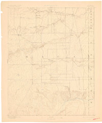
1892 Map of Vilas
USGS Topo · Published 1898About this map
Vilas and Boston anchor this late nineteenth-century reconnaissance of southeastern Colorado, where early cattle ranching and prairie settlement met the high plains. The landscape is defined by the ephemeral drainage systems of the Cimarron River and Sand Arroyo, alongside distinctive geological markers like Black Butte and Buffalo Point. A critical historical detail is the route of the Texas Trail, which cuts north-south across the landscape, marking the era of the great cattle drives through Baca County. The survey identifies foundational outposts such as Mathews Ranch and Miles Ranch, illustrating the transition from open range to established homesteads. To the east, the state line is clearly delineated as the Colorado-Kansas Boundary Line, separating the fledgling settlements of Stonington and Plymouth from the adjacent Stanton and Morton counties.
Find a feature on this map
23 named features on this map. Tap any name to fly to it.
Don’t see what you’re looking for? This feature index may not catch every label — zoom into the map to look around manually.
Map Details
Editions of this 1892 Vilas Map
5 editions found
Other maps of this area

1891 · Albany
USGS Topo · 1:125,000

1891 · Springfield
USGS Topo · 1:125,000

1892 · Vilas
USGS Topo · 1:125,000

1892 · Two Butte
USGS Topo · 1:125,000

1893 · Two Butte
USGS Topo · 1:125,000

1893 · Springfield
USGS Topo · 1:125,000

1893 · Albany
USGS Topo · 1:125,000

1900 · Syracuse
USGS Topo · 1:125,000

1920 · Syracuse
USGS Topo · 1:125,000

1954 · Perryton
USGS Topo · 1:250,000