1920 Map of Syracuse
USGS Topo · Published 1920About this map
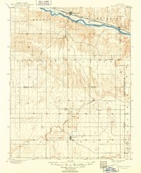
The Arkansas River corridor defines the geography of this western Kansas region, serving as the primary artery for both transportation and settlement. Following the northern bank, the Atchison Topeka and Santa Fe railroad connects the major hubs of Syracuse and Kendall, with smaller sidings like Mayline spaced along the tracks. Away from the river valley, the landscape is divided into named topographic districts like Lamont and Mitchell, where early agricultural outposts such as Hatton, Irene, and Menno appear as isolated settlements on the high plains.
Find a feature on this map
23 named features on this map. Tap any name to fly to it.
Don’t see what you’re looking for? This feature index may not catch every label — zoom into the map to look around manually.
Map Details
Editions of this 1920 Syracuse Map
This is the sole edition of this map. No revisions or reprints were ever made.