1894 Map of Granada
USGS Topo · Published 1894About this map
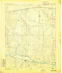
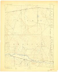
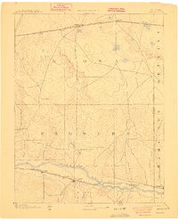
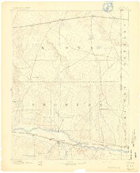
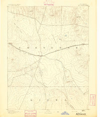
Arkansas River valley life in the late nineteenth century is defined by the parallel development of two major rail corridors. To the south, the Atchison Topeka & Santa Fe Railroad links the settlements of Carlton, Manville, and Granada, while the Missouri Pacific Railroad traverses the northern section of the map through Sheridan Lake and Towner. This era of western expansion is clearly visible in the establishment of rural outpostings like Ellis Ranch and Watsons Ranch, which sit between the prominent drainage systems of Big Sandy Creek and Wild Horse Creek. The map documents the precise placement of the Colorado Kansas Boundary Line, marking the transition into Greeley and Hamilton counties. Water remains the primary geographical anchor, with numerous named tributaries such as Buffalo Creek and Granada Creek feeding the main river channel as it flows east toward Coolidge.
Find a feature on this map
31 named features on this map. Tap any name to fly to it.
Don’t see what you’re looking for? This feature index may not catch every label — zoom into the map to look around manually.
Map Details
Editions of this 1894 Granada Map
4 editions found

Other maps of this area

1890 · Granada
USGS Topo · 1:125,000

1891 · Albany
USGS Topo · 1:125,000

1891 · Kit Carson
USGS Topo · 1:125,000

1892 · Lamar
USGS Topo · 1:125,000

1892 · Cheyenne Wells
USGS Topo · 1:125,000
1892 · Granada
USGS Topo · 1:125,000

1892 · Two Butte
USGS Topo · 1:125,000
1893 · Kit Carson
USGS Topo · 1:125,000

1893 · Two Butte
USGS Topo · 1:125,000
1893 · Albany
USGS Topo · 1:125,000