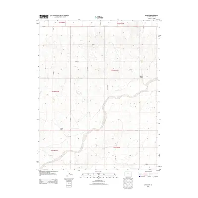
2013 Map of Midway SW
USGS Topo · Published 2013About this map
The Cimarron River winds through this section of Baca County, defining the drainage patterns of a landscape marked by deep natural depressions and breaks. Small seasonal waterways such as Spring Canyon, Moore Draw, and Mitchell Draw feed into the river basin, illustrating the complex topography that dictates local land use. While much of the area is carved by these watercourses, industrial activity is evident at the Flank Oil Field, representing the energy production that has shaped the regional economy. A strict grid of rural routes, including CO Road K and CO Road 48, provides access across the townships, highlighting the intersection of industrial development and the natural environment in the High Plains.
Find a feature on this map
27 named features on this map. Tap any name to fly to it.
Don’t see what you’re looking for? This feature index may not catch every label — zoom into the map to look around manually.
Map Details
Editions of this 2013 Midway SW Map
This is the sole edition of this map. No revisions or reprints were ever made.
Other maps of this area

1892 · Vilas
USGS Topo · 1:125,000

1954 · Dalhart
USGS Topo · 1:250,000

1955 · La Junta
USGS Topo · 1:250,000

1958 · La Junta
USGS Topo · 1:250,000

1958 · Dalhart
USGS Topo · 1:250,000

1962 · Dalhart
USGS Topo · 1:250,000

1968 · La Junta
USGS Topo · 1:250,000

1971 · Sturgis
USGS Topo · 1:24,000

1971 · Keyes NE
USGS Topo · 1:24,000
1971 · Sturgis NW
USGS Topo · 1:24,000