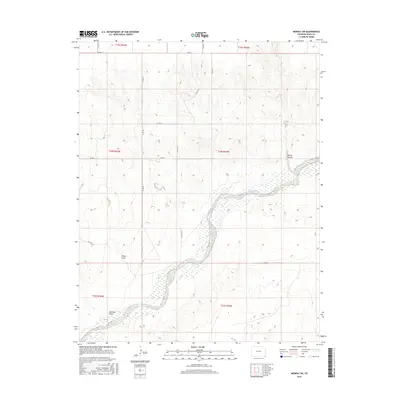
2016 Map of Midway SW
USGS Topo · Published 2016About this map
The Cimarron River winds through the southeastern corner of Colorado, carving a distinct corridor through the high plains of Baca County. This 2016 survey illustrates the drainage patterns of the high desert, where ephemeral waterways like Spring Canyon, Moore Draw, and Mitchell Draw feed into the river valley. The landscape is defined by the Public Land Survey System grid, which dictates the placement of local thoroughfares such as Co RD 48 and Co RD K. These roads trace the section lines across townships like t34s r42w and t35s r43w, reflecting the long-standing agricultural and ranching layout of the region. The map provides a detailed view of the terrain's subtle elevation changes, showing how local coulees and draws shape the rural infrastructure far from major urban centers.
Find a feature on this map
21 named features on this map. Tap any name to fly to it.
Don’t see what you’re looking for? This feature index may not catch every label — zoom into the map to look around manually.
Map Details
Editions of this 2016 Midway SW Map
This is the sole edition of this map. No revisions or reprints were ever made.
Other maps of this area

1892 · Vilas
USGS Topo · 1:125,000

1954 · Dalhart
USGS Topo · 1:250,000

1955 · La Junta
USGS Topo · 1:250,000

1958 · La Junta
USGS Topo · 1:250,000

1958 · Dalhart
USGS Topo · 1:250,000

1962 · Dalhart
USGS Topo · 1:250,000

1968 · La Junta
USGS Topo · 1:250,000

1971 · Sturgis
USGS Topo · 1:24,000

1971 · Keyes NE
USGS Topo · 1:24,000
1971 · Sturgis NW
USGS Topo · 1:24,000