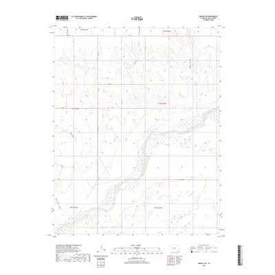
2019 Map of Midway SW
USGS Topo · Published 2019About this map
The Cimarron River winds through the southwestern corner of this Baca County landscape, defining the local drainage system alongside deep topographic depressions like Mitchell Draw and Moore Draw. The map reveals a strictly organized grid of rural infrastructure, where local county roads such as Co RD 48, Co RD 49, and Co Rd G follow section lines across the high plains. In the northeast, the terrain is incised by Spring Canyon, which breaks the otherwise uniform township and range blocks. This area is characterized by large-scale agricultural or grazing tracts, typical of the Colorado borderlands, with little to no concentrated settlement. The presence of numerous intermittent drainage features and the broad bed of the Cimarron River suggest a landscape shaped by infrequent but significant water events in an arid environment.
Find a feature on this map
20 named features on this map. Tap any name to fly to it.
Don’t see what you’re looking for? This feature index may not catch every label — zoom into the map to look around manually.
Map Details
Editions of this 2019 Midway SW Map
This is the sole edition of this map. No revisions or reprints were ever made.
Other maps of this area

1892 · Vilas
USGS Topo · 1:125,000

1954 · Dalhart
USGS Topo · 1:250,000

1955 · La Junta
USGS Topo · 1:250,000

1958 · La Junta
USGS Topo · 1:250,000

1958 · Dalhart
USGS Topo · 1:250,000

1962 · Dalhart
USGS Topo · 1:250,000

1968 · La Junta
USGS Topo · 1:250,000

1971 · Sturgis
USGS Topo · 1:24,000

1971 · Keyes NE
USGS Topo · 1:24,000
1971 · Sturgis NW
USGS Topo · 1:24,000