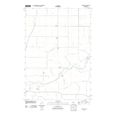
2010 Map of Miesville
USGS Topo · Published 2010About this map
Miesville serves as the central hub of this agricultural landscape in southeastern Minnesota, where the township's straight-grid section lines meet the winding path of the Cannon River. This 2010 survey reveals a community deeply connected to its land and heritage, marked by local landmarks like the Saint Joseph Catholic Cemetery and the Elmdale Hills Golf Course. The river corridor provides a distinct break in the prairie topography, creating the Clark Valley and offering recreational spaces such as the Hidden Valley Campgrounds and the Cannon Valley Trl. Researchers will find significant genealogical value in the multiple burial sites documented, including the Cannon River Church Cemetery and Cannon River Cemetery, which reflect the area's early settlement patterns. Transportation and leisure also converge here, with the Stewart Farms Airport and the southern entry of Belle Creek highlighting the region's diverse rural economy.
Find a feature on this map
44 named features on this map. Tap any name to fly to it.
Don’t see what you’re looking for? This feature index may not catch every label — zoom into the map to look around manually.
Map Details
Editions of this 2010 Miesville Map
This is the sole edition of this map. No revisions or reprints were ever made.
Other maps of this area

1944 · Red Wing
USGS Topo · 1:62,500

1952 · Red Wing
USGS Topo · 1:62,500

1953 · Saint Paul
USGS Topo · 1:250,000

1957 · Hastings
USGS Topo · 1:62,500

1959 · Saint Paul
USGS Topo · 1:250,000

1968 · Sogn
USGS Topo · 1:24,000

1968 · White Rock
USGS Topo · 1:24,000
1968 · Goodhue West
USGS Topo · 1:24,000
1974 · Cannon Falls
USGS Topo · 1:24,000
1974 · Miesville
USGS Topo · 1:24,000