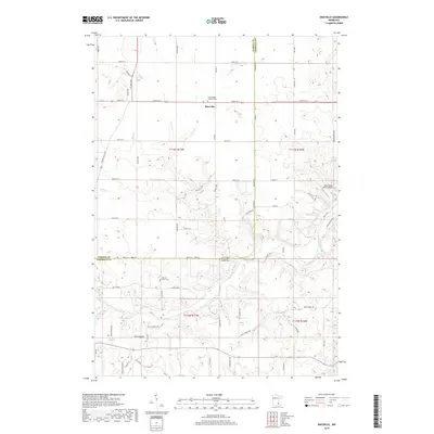
2019 Map of Miesville
USGS Topo · Published 2019About this map
Miesville serves as the primary hub on this Dakota County landscape, where the agricultural uplands begin their descent toward the river valley. The settlement is anchored by Saint Joseph Catholic Cem, reflecting the deep-rooted community history of this township. To the south, the terrain becomes increasingly complex as it meets the Cannon River, a significant waterway that carves through the southern portion of the map. Along the river's path, local heritage is preserved at the Cannon River Lutheran Church Cem and the nearby Cannon River Cem. The map illustrates a shift from the orderly grid of county roads like Co Rd 91 and 240th St E to the winding trails of Clark Valley, where the elevation drops toward the Belle Cr drainage. Small-scale aviation is represented by the River Ridge Ranch Airport, situated on the eastern edge of the quadrangle.
Find a feature on this map
60 named features on this map. Tap any name to fly to it.
Don’t see what you’re looking for? This feature index may not catch every label — zoom into the map to look around manually.
Map Details
Editions of this 2019 Miesville Map
This is the sole edition of this map. No revisions or reprints were ever made.
Other maps of this area

1944 · Red Wing
USGS Topo · 1:62,500

1952 · Red Wing
USGS Topo · 1:62,500

1953 · Saint Paul
USGS Topo · 1:250,000

1957 · Hastings
USGS Topo · 1:62,500

1959 · Saint Paul
USGS Topo · 1:250,000

1968 · Sogn
USGS Topo · 1:24,000

1968 · White Rock
USGS Topo · 1:24,000
1968 · Goodhue West
USGS Topo · 1:24,000
1974 · Cannon Falls
USGS Topo · 1:24,000
1974 · Miesville
USGS Topo · 1:24,000