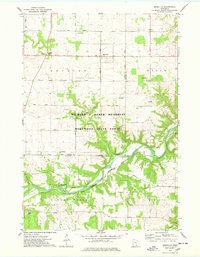
1974 Map of Miesville
USGS Topo · Published 1978About this map
The Cannon River winds through the heart of this mid-1970s landscape, carving a deep valley that defines the border between Dakota and Goodhue counties. This corridor is dominated by the Richard J Dorer Memorial Hardwood State Forest, showing a preserved landscape of steep bluffs and wooded ravines. Along the southern banks, the Chicago Milwaukee St Paul and Pacific railroad tracks trace the river's path, serving as a reminder of the area's vital transportation history.
Find a feature on this map
31 named features on this map. Tap any name to fly to it.
Don’t see what you’re looking for? This feature index may not catch every label — zoom into the map to look around manually.
Map Details
Editions of this 1974 Miesville Map
This is the sole edition of this map. No revisions or reprints were ever made.
Other maps of this area

1944 · Red Wing
USGS Topo · 1:62,500

1952 · Red Wing
USGS Topo · 1:62,500

1953 · Saint Paul
USGS Topo · 1:250,000

1957 · Hastings
USGS Topo · 1:62,500

1959 · Saint Paul
USGS Topo · 1:250,000

1968 · Sogn
USGS Topo · 1:24,000

1968 · White Rock
USGS Topo · 1:24,000
1968 · Goodhue West
USGS Topo · 1:24,000
1974 · Cannon Falls
USGS Topo · 1:24,000
1974 · Vermillion
USGS Topo · 1:24,000