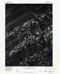
1977 Map of Mifflintown
USGS Topo · Published 1979About this map
Mifflintown and its twin borough of Mifflin sit at the center of this orthophotoquad, separated by the wide ribbon of the Juniata River. This 1977 aerial survey captures the Juniata Valley at a time when traditional agricultural patterns remained clearly etched into the land, visible as long, narrow strip-farmed fields that climb the lower slopes of Shade Mountain and Blue Mountain. The imagery highlights the strategic importance of the river gap, where the local water system is augmented by Lost Creek and Tuscarora Creek. The distinct contrast between the forested ridges and the highly productive, variegated river bottom lands illustrates the geographical constraints that shaped the development of these Juniata County communities. This perspective reveals the density of the town centers and the transportation corridor following the river's bend, including the paths of Route 322 and Route 75.
Find a feature on this map
10 named features on this map. Tap any name to fly to it.
Don’t see what you’re looking for? This feature index may not catch every label — zoom into the map to look around manually.
Map Details
Editions of this 1977 Mifflintown Map
This is the sole edition of this map. No revisions or reprints were ever made.
Other maps of this area

1919 · Mattawana
USGS Topo · 1:62,500

1924 · Lewistown
USGS Topo · 1:62,500

1925 · Mifflintown
USGS Topo · 1:48,000

1927 · Lewisburg
USGS Topo · 1:62,500

1930 · Loysville
USGS Topo · 1:62,500

1933 · Loysville
USGS Topo · 1:62,500

1934 · Mifflintown
USGS Topo · 1:62,500

1936 · East Waterford
USGS Topo · 1:48,000

1937 · Mifflintown
USGS Topo · 1:62,500

1941 · East Waterford
USGS Topo · 1:62,500