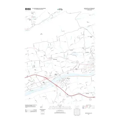
2013 Map of Mifflinville
USGS Topo · Published 2013About this map
The Susquehanna River defines the southern portion of this Columbia County landscape, where the settlement of Mifflinville sits on the southern bank opposite French Island. To the north, the terrain is shaped by the parallel ridges of Knob Mountain and Lee Mountain, with several small communities like Fowlersville, Evansville, and Martzville following the east-west orientation of the valleys. This 2013 survey shows a mix of agricultural land and suburban growth, with aviation infrastructure at Seesholtz Airport and recreation at the Wolf Hollow Golf Course. Numerous smaller drainages including Fishing Cr, Huntington Cr, and the branches of Briar Cr carve through the northern hills, while the larger Tenmile Run flows south toward the river. The map also documents local landmarks like Pealertown and the Youth Camp near Geisinger Hollow.
Find a feature on this map
199 named features on this map. Tap any name to fly to it.
Don’t see what you’re looking for? This feature index may not catch every label — zoom into the map to look around manually.
Map Details
Editions of this 2013 Mifflinville Map
This is the sole edition of this map. No revisions or reprints were ever made.
Other maps of this area

1889 · Catawissa
USGS Topo · 1:62,500

1892 · Catawissa
USGS Topo · 1:62,500

1892 · Mahanoy
USGS Topo · 1:62,500

1893 · Mahanoy
USGS Topo · 1:62,500

1894 · Catawissa
USGS Topo · 1:62,500

1894 · Shickshinny
USGS Topo · 1:62,500

1894 · Bloomsburg
USGS Topo · 1:62,500

1946 · Shickshinny
USGS Topo · 1:31,680

1946 · Berwick
USGS Topo · 1:31,680

1947 · Bloomsburg
USGS Topo · 1:24,000
Featured Places
- Berwick, PA
- North Centre Township, PA
- Briar Creek, PA
- Main Township, PA
- Pealertown, Fishing Creek Township