
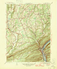
1946 Map of Shickshinny
USGS Topo · Published 1946About this map
The Susquehanna River cuts a deep gap through Shickshinny Mountain and Huntington Mountain in this mid-century Pennsylvania portrait. The riverfront communities of Shickshinny and Mocanaqua are connected by bridge, with the Pennsylvania railroad running along the eastern bank. North and west of these steep ridges, the terrain transitions into a mosaic of small farming settlements and upland valleys. Local history is richly detailed through a network of rural schoolhouses and churches, including the Sunshine School and Bloomingdale Church. Huntington Creek winds through the western portion of the map, powering sites like Koons Dam near Huntington Mills. The map also captures several family-named landmarks and cemeteries, such as the Sorber Cemetery and Patterson Grove, which reflect the established genealogical roots of Luzerne and Columbia counties during this era.
Find a feature on this map
56 named features on this map. Tap any name to fly to it.
Don’t see what you’re looking for? This feature index may not catch every label — zoom into the map to look around manually.
Map Details
Editions of this 1946 Shickshinny Map
2 editions found
Other maps of this area

1891 · Harveys Lake
USGS Topo · 1:62,500

1893 · Harvey Lake
USGS Topo · 1:62,500

1894 · Shickshinny
USGS Topo · 1:62,500

1894 · Bloomsburg
USGS Topo · 1:62,500

1934 · Laporte
USGS Topo · 1:62,500

1946 · Sybertsville
USGS Topo · 1:31,680

1946 · Nanticoke
USGS Topo · 1:31,680

1946 · Berwick
USGS Topo · 1:31,680

1946 · Harveys Lake
USGS Topo · 1:24,000

1946 · Sweet Valley
USGS Topo · 1:24,000
Featured Places
- Hunlock Township, PA
- Conyngham Township, PA
- Shickshinny, PA
- Briar Creek Township, PA
- Muhlenburg, Union Township