
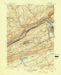
1946 Map of Nanticoke
USGS Topo · Published 1946About this map
The Susquehanna River carves a deep valley through the center of this 1940s landscape, serving as the corridor for the Pennsylvania RR and the Delaware Lackawanna and Western RR. Parallel to the river's northern bank lies the Pennsylvania Canal (Abandoned), a relic of earlier transportation history. The valley is anchored by Nanticoke and West Nanticoke, while heavy industry and mining activity are suggested by the concentrated settlements of Glen Lyon, Wanamie, and Alden to the south.
Find a feature on this map
53 named features on this map. Tap any name to fly to it.
Don’t see what you’re looking for? This feature index may not catch every label — zoom into the map to look around manually.
Map Details
Editions of this 1946 Nanticoke Map
2 editions found
Other maps of this area

1891 · Wilkesbarre
USGS Topo · 1:62,500

1891 · Harveys Lake
USGS Topo · 1:62,500

1893 · Harvey Lake
USGS Topo · 1:62,500

1893 · Pittston
USGS Topo · 1:62,500

1894 · Shickshinny
USGS Topo · 1:62,500

1894 · Wilkesbarre
USGS Topo · 1:62,500

1943 · Scranton
USGS Topo · 1:125,000

1946 · Sybertsville
USGS Topo · 1:31,680

1946 · Shickshinny
USGS Topo · 1:31,680

1946 · Berwick
USGS Topo · 1:31,680