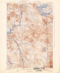
1934 Map of Milan
USGS Topo · Published 1934About this map
The Androscoggin River dominates this Coos County landscape, cutting a deep valley through the northern White Mountains region. During this era, the river served as a vital corridor for both transport and industry, flanked by the State Highway and a series of rural schools including the Jewett Sch and Willis Sch. The settlement of Milan serves as a local hub, while the presence of the Berlin Landing Field indicates the early development of regional aviation infrastructure. To the east, the terrain becomes increasingly complex as it approaches the Maine border, featuring the notable Mahoosuc Notch and the beginning of the Mahoosuc Notch Trail. In the northern reach, Umbagog Lake and its various coves like Thurston Cove mark the transition toward the northern wilderness, reflecting a landscape defined by timber, water power, and early recreational hiking.
Find a feature on this map
82 named features on this map. Tap any name to fly to it.
Don’t see what you’re looking for? This feature index may not catch every label — zoom into the map to look around manually.
Map Details
Editions of this 1934 Milan Map
2 editions found

Other maps of this area

1893 · Mt. Washington
USGS Topo · 1:62,500

1893 · Gorham
USGS Topo · 1:62,500

1896 · Mt. Washington
USGS Topo · 1:62,500

1896 · Gorham
USGS Topo · 1:62,500

1914 · Bethel
USGS Topo · 1:62,500

1930 · Milan
USGS Topo · 1:62,500

1930 · Percy
USGS Topo · 1:62,500

1930 · Dixville
USGS Topo · 1:62,500

1930 · Errol
USGS Topo · 1:62,500

1933 · Dixville
USGS Topo · 1:62,500