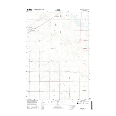
2015 Map of Milbank East
USGS Topo · Published 2015About this map
Milbank anchors the northwest corner of this South Dakota landscape, where the town's early footprint is marked by the Saint Lawrence Cem and Milbank Cem. The eastern edge of the community transitions into the Milbank Municipal Airport before giving way to the expansive agricultural grid of Grant County. This layout of section lines and gravel roads, including Landfill RD and Schumacher RD, reveals the persistent 19th-century land survey system that still dictates modern movement. To the east, the waters of Lake Albert provide a natural break in the prairie, while the N Fork Yellow Bank River meanders across the southern townships. The map documents the rural infrastructure of the mid-2010s, from the localized street names like Morningside DR and Aspen DR in the growing residential areas to the long stretches of numbered county avenues that connect the surrounding farmsteads.
Find a feature on this map
71 named features on this map. Tap any name to fly to it.
Don’t see what you’re looking for? This feature index may not catch every label — zoom into the map to look around manually.
Map Details
Editions of this 2015 Milbank East Map
This is the sole edition of this map. No revisions or reprints were ever made.
Other maps of this area

1953 · Ortonville
USGS Topo · 1:62,500

1953 · Bellingham
USGS Topo · 1:62,500

1953 · Milbank
USGS Topo · 1:250,000

1954 · Big Stone Lake
USGS Topo · 1:62,500

1958 · Milbank
USGS Topo · 1:250,000

1971 · Marietta
USGS Topo · 1:24,000

1971 · Rosen
USGS Topo · 1:24,000

1971 · Big Stone Lake SE
USGS Topo · 1:24,000

1971 · Big Stone Lake SW
USGS Topo · 1:24,000
1971 · Ortonville
USGS Topo · 1:24,000