
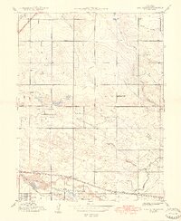
1942 Map of Mile High Lakes
USGS Topo · Published 1942About this map
Agricultural development and water management define this High Plains landscape east of the Rockies, where a complex network of man-made waterways supports the region's ranching economy. The Barr Lake (Reservoir) dominates the western edge, feeding into an intricate system of gravity-fed irrigation channels including the Hudson Canal, East Burlington Canal, and the Denver-Hudson Canal. These engineering works transformed the naturally arid terrain around Third Creek and Grass Valley Creek into productive land for family operations like the Miliken Ranch, Patton Ranch, and Chapman Ranch.
Find a feature on this map
24 named features on this map. Tap any name to fly to it.
Don’t see what you’re looking for? This feature index may not catch every label — zoom into the map to look around manually.
Map Details
Editions of this 1942 Mile High Lakes Map
This is the sole edition of this map. No revisions or reprints were ever made.
Other maps of this area

1890 · East Denver
USGS Topo · 1:125,000

1902 · Greeley
USGS Topo · 1:125,000

1938 · Long Branch
USGS Topo · 1:24,000

1940 · Brighton
USGS Topo · 1:31,680

1941 · Long Branch
USGS Topo · 1:31,680

1942 · Box Elder School
USGS Topo · 1:31,680

1944 · Brighton
USGS Topo · 1:31,680
1948 · Long Branch
USGS Topo · 1:24,000

1949 · Fort Lupton
USGS Topo · 1:24,000

1949 · Hudson
USGS Topo · 1:24,000